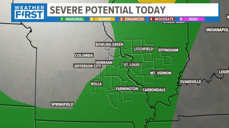
ST. LOUIS — The National Weather Service today upgraded the St. Louis metropolitan area to a Level 4 out of 5 threat for severe weather, urging residents to prepare for potentially widespread hazardous conditions, including strong tornadoes, very large hail, and damaging winds, beginning late Tuesday evening and continuing into Wednesday morning.
This significant upgrade places the region, encompassing communities across both Missouri and Illinois, under a heightened risk for what forecasters describe as a particularly dangerous situation. The NWS Storm Prediction Center highlighted atmospheric conditions highly conducive to the rapid development of destructive thunderstorms.
Officials with the National Weather Service office in St. Louis emphasized the need for immediate preparedness. "This is not a drill," stated Chief Meteorologist Dr. Eleanor Vance during an afternoon press briefing. "The ingredients are aligning for a high-impact event, and everyone in the St. Louis region must have a plan and be ready to act on it as soon as warnings are issued."
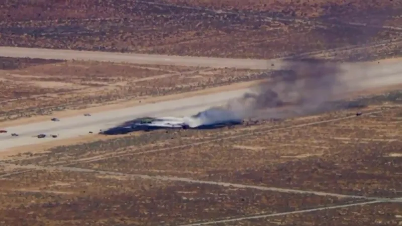
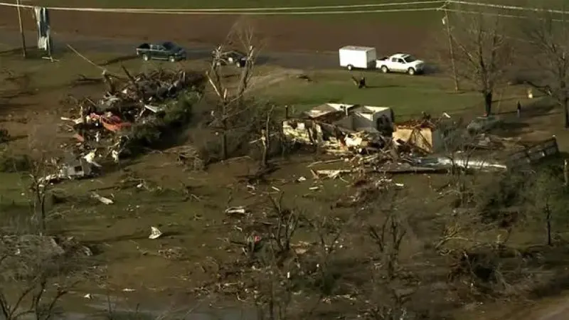
The primary threats include tornadoes, some of which could be long-track and intense, capable of causing significant damage. Hail stones are projected to reach golf-ball to baseball size, posing risks to property and personal safety. Straight-line winds exceeding 70 miles per hour are also anticipated.
Emergency management agencies across the bi-state area have activated their command centers and are coordinating resources. Local authorities are urging residents to review their severe weather plans, identify safe rooms or shelters, and ensure weather alert systems are operational.
"We are working closely with all first responders and utility companies to minimize potential disruptions and respond quickly to any emergencies," said Sarah Jenkins, Director of St. Louis County Emergency Management. "Our message is clear: monitor official forecasts, have multiple ways to receive alerts, and know where you will go when a warning is issued."
School districts throughout the St. Louis region have begun issuing advisories, with some considering early dismissals or closures for Wednesday, depending on the evolving forecast. Public transportation authorities are also developing contingency plans for potential service interruptions.
Historically, the St. Louis area has experienced devastating severe weather events, making this Level 4 upgrade a serious concern for both public safety officials and the populace. The last time the region faced such an elevated threat level was during the spring of 2011, which saw several destructive tornado outbreaks across the Midwest.
Residents are advised to secure loose outdoor items, charge all electronic devices, and prepare emergency kits with essentials such as water, non-perishable food, flashlights, and a battery-powered radio. Pet owners should also ensure their animals have a safe place during the storms.
The National Weather Service will continue to provide frequent updates through their official channels, local news outlets, and social media. Citizens are encouraged to rely solely on these verified sources for the most accurate and timely information regarding the St. Louis region upgraded to a level 4 out of 5 threat for severe weather.