WASHINGTON — Millions of Americans are bracing for an unprecedented triple-threat megastorm poised to unleash heavy snow, damaging high winds, and widespread thunder across large sections of the continental United States starting Wednesday. The severe weather event, anticipated to disrupt travel and critical infrastructure for days, has prompted emergency declarations and urgent warnings from federal meteorological agencies.
The National Weather Service (NWS) issued a dire forecast Tuesday, detailing a complex atmospheric collision expected to generate blizzard conditions in the Midwest, powerful wind gusts reaching hurricane force in the Plains, and significant snowfall extending into the Northeast. Meteorologists indicate the storm’s unique confluence of elements presents a significant challenge for preparedness.
President Donald Trump received a briefing on the developing situation from Homeland Security officials and the Federal Emergency Management Agency (FEMA) this morning. A White House statement affirmed the administration’s commitment to supporting affected states, emphasizing coordination between federal and local emergency response teams.
The storm system is forming from a potent combination: a surge of arctic air descending from Canada colliding with a stream of warm, moisture-laden air originating from the Gulf of Mexico. This dynamic interaction fuels the intense precipitation, rapid temperature drops, and cyclonic wind patterns characteristic of the impending triple-threat megastorm.
Forecasters are particularly concerned about the rapid intensification of the low-pressure system, predicting rapid pressure drops that could lead to widespread thundersnow — a rare phenomenon combining heavy snowfall with lightning and thunder. This unusual combination magnifies the danger for utility crews and first responders.
Travel advisories have been issued across more than a dozen states, with major airlines already canceling thousands of flights nationwide. Interstate highways in key affected regions are expected to face closures due to whiteout conditions and hazardous driving. Officials urged citizens to complete essential preparations by late Tuesday evening.
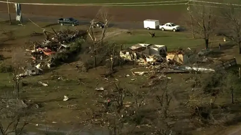
Energy providers are mobilizing extra crews, anticipating extensive power outages as high winds combine with heavy, wet snow to fell trees and damage utility lines. Residents are advised to secure loose outdoor items, charge electronic devices, and prepare emergency kits containing food, water, and alternative heating sources.
Agricultural sectors in the central plains, already grappling with fluctuating weather patterns, face potential losses as livestock and early spring crops could be severely impacted by extreme cold and blizzard conditions. Ranchers are taking proactive measures to shelter animals and secure feed supplies.
Emergency services, including state highway patrols and local fire departments, are on high alert. Many communities have activated warming shelters and are coordinating efforts to assist vulnerable populations, especially the elderly and those without adequate housing, who face severe hypothermia risks.
Dr. Evelyn Reed, a lead meteorologist at the NWS Weather Prediction Center, described the incoming system as "a truly exceptional and volatile event. Its multi-faceted nature demands a heightened level of caution and preparation from everyone in its path. We urge adherence to all official guidance."
Public safety announcements are saturating local media channels, reiterating the importance of avoiding unnecessary travel during the storm’s peak. School districts in anticipation of the severe weather are announcing closures for Thursday and possibly Friday.
The economic impact of such a widespread disruption could be substantial, affecting supply chains, retail operations, and daily commerce across affected states. Businesses are encouraging remote work where possible to minimize travel risks for employees.
The storm’s trajectory suggests its initial severe impact will be felt in the Mountain West before propagating eastward across the Midwest and into parts of the Great Lakes region and the Northeast. The exact timing and intensity will vary by location, but the overall threat remains consistent.
Citizens are encouraged to monitor local weather updates closely and heed evacuation orders if issued. The NWS website and emergency broadcasting system remain primary sources for real-time information and safety directives.
This event underscores the growing complexity of weather patterns observed in recent years, prompting ongoing discussions among climate scientists regarding the frequency and intensity of extreme weather phenomena.