Gabriella
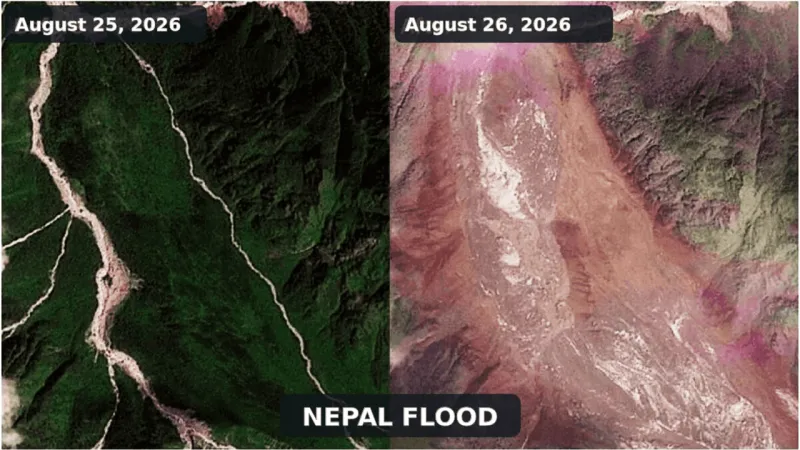
KATHMANDU, Nepal — Advanced satellite imagery from the European Unions Copernicus program has unveiled the dramatic scale of destruction wrought by a flash flood that ravaged the Nepal-Tibet border region on August 26. The powerful deluge, which struck without significant warning, transformed landscapes, triggering extensive landslides and altering river courses, a comparison of before-and-after images starkly reveals.
The Copernicus program, a cornerstone of European space initiatives, deployed its sophisticated observation capabilities to map the profound environmental changes. These visual data points offer objective, verifiable evidence of the catastrophic impact across the remote Himalayan terrain, providing crucial insights for disaster assessment and response teams.
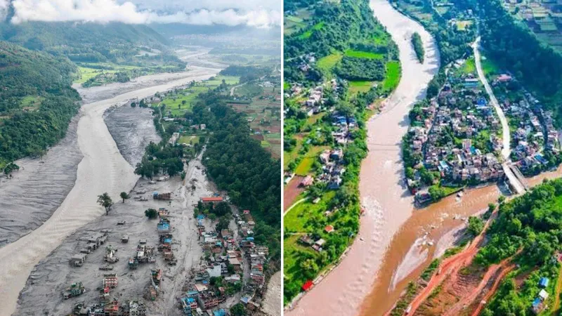
Preliminary analysis of the imagery indicates widespread devastation to valleys and riverbanks, where communities once thrived. Infrastructure, including roads and vital bridges, appears obliterated in many areas, severely hampering rescue operations and isolating affected populations. The sheer force of the water flow reshaped parts of the topography, illustrating the immense power unleashed by the deluge.
This incident follows a pattern of increasing extreme weather events in the vulnerable Himalayan ecosystem, a region highly susceptible to glacial lake outburst floods and intense monsoon rainfall. Experts continue to investigate the precise triggers for this particular flash flood, though the broader context suggests a confluence of meteorological factors and environmental degradation.
Satellite monitoring, such as that provided by Copernicus Sentinel missions, has become indispensable for tracking such rapid-onset disasters. The ability to acquire high-resolution images both before and immediately after an event allows for precise mapping of affected areas, assessment of damage, and identification of safe routes for aid workers.
The human toll of the August 26 event remains a pressing concern. While specific casualty figures are still being compiled, the scale of the destruction suggests significant loss of life and displacement. Reports have emerged detailing the harrowing experiences of survivors, and families desperately seek news of missing loved ones following the widespread chaos, including the reported disappearance of an Italian jeweler in the Nepal disaster.
The geographic complexities of the Nepal-Tibet border region further complicate relief efforts. Many affected areas are remote and difficult to access even under normal circumstances. Landslides, a common consequence of such flash floods, have further cut off routes, making the delivery of essential supplies a formidable challenge for authorities and aid organizations alike.
This flash flood adds to the grim chronicle of natural disasters impacting the region. Just recently, the area grappled with a glacier catastrophe that triggered a devastating Himalayan flash flood, highlighting the ongoing environmental instability. The frequency and intensity of these events underscore the urgent need for enhanced regional preparedness and resilience strategies.
International organizations and local governments are mobilizing resources, utilizing the satellite data to guide their efforts. The images serve as a stark reminder of the fragile balance within the Himalayan environment and the escalating risks faced by communities residing there. The challenge of recovery in this rugged terrain will be immense, demanding sustained national and international collaboration.
The August 26 flood and its aftermath reinforce the critical role of advanced remote sensing technologies in disaster management. As the region faces an unpredictable climate future, the insights provided by programs like Copernicus will be ever more vital for safeguarding lives, coordinating responses, and informing long-term environmental planning. The Himalayan flood toll mounts amid fears of a second deluge, emphasizing the ongoing volatility.