 Dodi Irawan
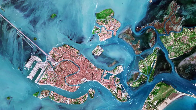
VENICE – High-resolution satellite observations from the recently deployed Iride constellation are providing an unprecedented view into the dynamic and often subtle chromatic variations of the Venice lagoon, meticulously mapping boat wakes and revealing the intricate tapestry of its salt marshes. This advanced imagery offers scientists and conservationists a critical new tool for monitoring one of the world's most vulnerable and ecologically significant aquatic environments.
The Iride constellation, an ambitious Italian-led initiative, represents a significant leap in Earth observation technology. Comprising a network of state-of-the-art satellites, it is engineered to deliver precise, frequent data on various terrestrial and aquatic phenomena, from detailed topographical mapping to the subtle shifts in water quality. Its capabilities far exceed previous generations of observational platforms, offering finer spatial and temporal resolutions.
The vibrant colors captured by these satellites are more than mere aesthetic features; they serve as crucial indicators of the lagoon's health and ecological processes. Distinct hues reflect varying concentrations of phytoplankton, sediment load, water depth, and even potential pollutants. These spectral signatures allow experts to differentiate between healthy algal blooms, industrial runoff, and natural detritus, providing a comprehensive diagnostic picture.
One particularly striking aspect revealed by the Iride data is the clear visibility of boat wakes traversing the lagoon. These persistent trails offer direct evidence of human activity and its physical impact on the delicate aquatic substrate. Scientists can analyze these patterns to understand navigation intensity, route adherence, and the potential for erosion in sensitive areas, contributing vital information for traffic management strategies.
The detailed mapping of the lagoon's expansive salt marshes also stands out as a key benefit of the new satellite technology. These biologically rich wetlands act as natural buffers against storm surges, purify water, and serve as critical habitats for numerous species. Tracking their extent, health, and any changes due to erosion or sedimentation is paramount for the long-term ecological stability of the Venetian ecosystem.
This satellite intelligence extends beyond mere observation, playing a crucial role in broader environmental monitoring efforts across Italy and the Mediterranean. By integrating Iride data with ground-based measurements and historical records, researchers can construct robust models predicting future environmental trajectories, particularly concerning the impacts of climate change.
Venice, a UNESCO World Heritage site, confronts severe threats from rising sea levels, increased flood events, and the pressures of mass tourism. Understanding the intricate hydrological and ecological dynamics of its lagoon is more urgent than ever. The satellite data provides an objective, large-scale perspective that is difficult, if not impossible, to achieve through traditional field surveys alone.
The insights gleaned from the Iride constellation are expected to directly inform the formulation and refinement of conservation and management strategies for the lagoon. This includes optimizing MOSE flood barrier operations, guiding dredging activities, and establishing more effective policies for environmental protection and sustainable tourism. Such data-driven decisions are vital for the city's continued existence.
Experts foresee the methodologies developed for the Venice lagoon becoming a blueprint for monitoring other vulnerable coastal regions worldwide. The success of the Iride constellation in delivering actionable intelligence for such a complex environment could pave the way for similar satellite initiatives focused on deltas, estuaries, and other critical maritime ecosystems facing similar anthropogenic and climatic pressures.
"The ability to observe the Venice lagoon with this level of detail and frequency from space is a game-changer for conservation," stated Dr. Elena Rossi, a leading marine biologist specializing in Adriatic ecosystems. "We can now identify subtle changes that would have previously gone unnoticed, allowing for much more proactive intervention."
Dr. Rossi emphasized the role of advanced analytics in processing the vast datasets. "The raw images are only the beginning. Sophisticated algorithms and artificial intelligence are transforming these pixels into meaningful ecological insights, helping us understand the interconnectedness of water flow, sediment transport, and biological activity across the entire lagoon."
The deployment of the Iride constellation underscores Italy's growing commitment to space technology and its application for societal benefit. This national investment positions Italy at the forefront of remote sensing capabilities, contributing not only to its own environmental stewardship but also to global scientific understanding of complex aquatic environments.
While the technology offers immense promise, challenges remain in translating data into immediate, effective policy changes. Public awareness and political will are crucial for implementing the conservation measures informed by these sophisticated observations. The long-term success hinges on sustained collaboration between scientists, policymakers, and local communities.
The data also provides compelling visual evidence for public engagement campaigns, illustrating the fragile beauty of the lagoon and the constant threats it faces. By making these stunning satellite images accessible, proponents hope to foster a deeper appreciation and a greater sense of urgency among residents and visitors alike regarding its preservation.