Gabriella
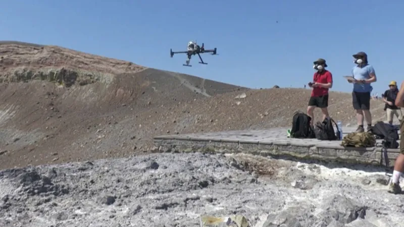
A groundbreaking scientific collaboration between leading German universities and Frances Centre National de la Recherche Scientifique (CNRS) has initiated an advanced project utilizing sophisticated drones to monitor volcanic gas emissions on Vulcano island, off the coast of Sicily. This innovative endeavor aims to significantly enhance the prediction of volcanic eruptions, with an ultimate goal of extending its application to the more imposing Mount Etna.
The initiative represents a critical leap forward in volcanology, employing unmanned aerial vehicles equipped with highly sensitive sensors. These drones collect real-time data on gas composition and concentrations, providing insights into the subterranean processes that precede volcanic activity. Traditional ground-based monitoring can be hazardous and geographically limited, but drones offer unparalleled access to difficult and dangerous crater environments.
Researchers are particularly interested in sulfur dioxide, carbon dioxide, and hydrogen sulfide levels, which are key indicators of magma movement and pressure changes beneath the surface. By establishing a baseline and detecting anomalies in these emissions, scientists hope to develop more precise models for anticipating when a volcano might erupt, giving authorities more time for evacuation and safety measures.
The project commenced on Vulcano, an island whose name itself is synonymous with geological activity. Its last major eruption occurred in the late 19th century, but it remains a perpetually active fumarolic field, demanding continuous vigilance. The island serves as an ideal living laboratory for refining the drone technology and data analysis protocols before scaling up to larger, more complex systems.
Upon successful validation and optimization on Vulcano, the research will pivot towards Mount Etna, one of the worlds most active and iconic volcanoes. Etna, which frequently experiences effusive eruptions, presents unique challenges due to its vast size, varied terrain, and higher altitude, necessitating robust and adaptable drone systems capable of operating in diverse meteorological conditions.
The ability to conduct aerial surveys repeatedly and systematically promises to mitigate risks for volcanologists who historically have had to brave hazardous conditions to collect samples manually. The drones can penetrate plumes that are too dangerous for human proximity, retrieving invaluable data from the heart of the volcanic system without endangering lives.
This international scientific partnership underscores a global commitment to understanding and mitigating natural disasters. Germany and France bring complementary expertise in aerospace engineering, sensor development, and geophysical modeling, forging a powerful alliance against the unpredictable forces of nature.
Improved eruption prediction has far-reaching implications. For local populations residing near active volcanoes, it means enhanced safety protocols and the potential to prevent loss of life and property. For air travel, it can minimize disruptions caused by ash plumes, which can ground flights and cause significant economic impact across continents.
Italy, a country characterized by its active geological landscape, faces a constant need for advanced monitoring solutions. From its seismic zones to its numerous volcanoes, proactive measures are crucial. The nation has also often faced significant natural challenges, including intense heatwaves requiring red alerts across regions like Sardinia, making comprehensive environmental monitoring all the more vital.
The data harvested by these drones will feed into complex algorithms and machine learning models, allowing for the identification of subtle patterns that might otherwise go unnoticed. This statistical rigor will form the backbone of a new generation of early warning systems, moving beyond qualitative observations to quantitative, predictive science.
While the technology promises significant advancements, researchers acknowledge the inherent complexities of volcanic behavior. No two volcanoes are precisely alike, and external factors like seismic activity or heavy rainfall can influence their emissions. The project aims not for infallibility but for a substantial reduction in uncertainty.
The insights gained from Vulcano and Etna could serve as a blueprint for similar monitoring efforts worldwide, offering a standardized, cost-effective, and safe methodology for assessing volcanic threats in regions from the Pacific Ring of Fire to the African Rift Valley. This project heralds a future where humanity is better prepared to coexist with Earths dynamic and often volatile geological processes.